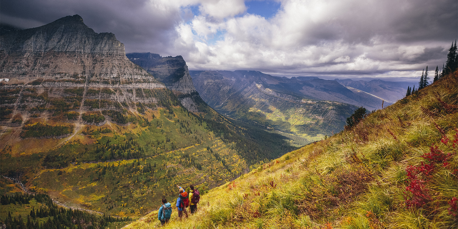

5 Top National Parks for Fishing
These five parks are best viewed from the water’s edge.
During President Obama’s 2016 spate of last-minute national monument designations (remember Bears Ears?), Katahdin Woods and Waters seemed like it slipped under the radar. Just east of popular Baxter State Park (home to Mount Katahdin itself, the state’s tallest peak), this protected plot covers 87,000-plus acres of northern Maine forests, whitewater-stacked rivers, pristine streams, and short but rocky, weather-ravaged peaks. Hidden away in the upper-right corner of the country, far from any big cities, the monument feels as remote as anywhere else in the lower 48 that you could explore. That sense of being overlooked helped it maintain its monument designation in the next administration. Since then, it’s steadily gained more attention as a true adventure destination in the Northeast. Here’s how to discover the pristine hiking trails, world-class stream fishing and paddling, cross-country skiing and more that make Katahdin Woods and Waters one of the best “out there” fringes of the otherwise densely populated New England region.
You’d be forgiven for thinking the top of Deasey Mountain is a lot taller than 1,942 feet of elevation. Thanks to its northern latitude, the summit provides hikers with a rocky alpine scene barren of all but few stunted trees—plus a heck of a view. A ground-level fire lookout is there for a reason: From this vantage, you can look down over most of the monument. Situated between the Wassataquoik and Penobscot rivers, the vast carpets of black spruce trees are broken only by old logging roads and ribbons of blue. To the west, Katahdin Lake and Mount Katahdin itself tower over the terrain.
To get there, start with a map of the monument to get oriented. Deasey sits near the middle, accessed from the end of a spur road leading north off the Katahdin Loop. Cross the Wassataquoik whenever convenient (the water is relatively shallow most of the year) and take a trail (unnamed) northeast to the base of the mountain. There, look for the cabin that once belonged to the fire observer before climbing to the summit. The whole hike is just over 10 miles round-trip.
The Wassataquoik (pronounced “wuh-SAW-ta-cook”) is a tributary to the larger East Branch Penobscot but holds some of the best (secret) fishing spots in an already secret-feeling monument. From the same trailhead as the hike up Deasey, follow a trail northwest, along the southern banks of the creek, looking for holes and pockets. The “official” trail ends at Orin Falls where you’ll also find campsites if you want to make an overnight of your brook trout-scouting mission.
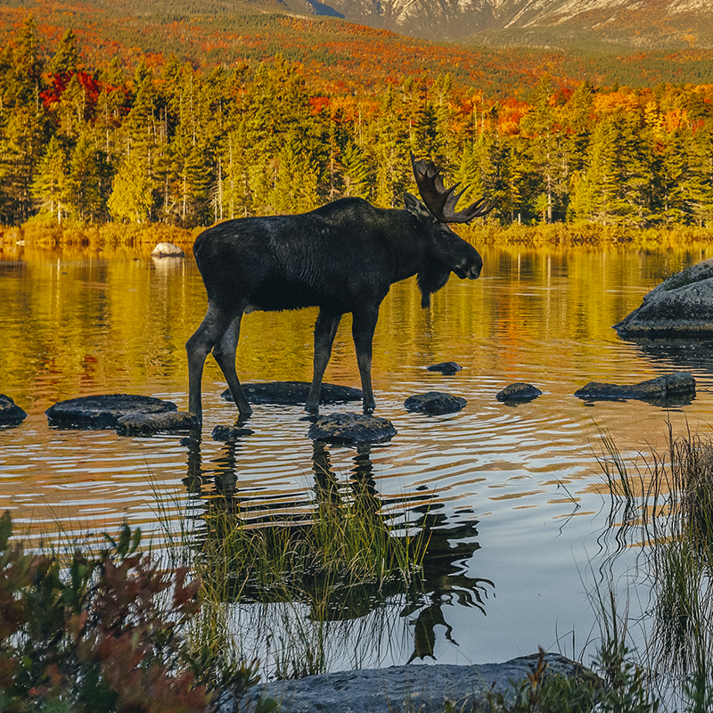 Photo: Paul
The lowlands of Katahdin Woods and Waters are peppered with dense forests and spruce boks, perfect habitat for Maine’s ultimate ungulate. But the density of the forests also encourages the local moose to use manmade thoroughfares to get around. The loop road in the southern end of the monument is one of those spots. The 19-mile dirt road begins at Sandbank Stream, following old logging roads through forests and bogs to a collection of overlooks peering west toward Mount Katahdin. Drive the road early in the morning for your best chance at spotting moose or bear.
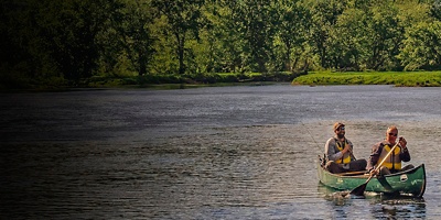
Even before Katahdin Woods and Waters was “put on the map” by a presidential declaration, locals knew it for the spectacular canoeing along the East Branch of the Penobscot River. Running north to south though the length of the monument, this paddling corridor mixes in scenic stretches of flatwater with rustic riverside campsites and thrilling “pitches” of whitewater (the most difficult short sections, easily portaged if you’re not equipped to roll or self-rescue, are typically Class III or IV, depending on the water level). Put on at the north end, where Grand Lake Road crosses the river below the outlet of Grand Lake Matagamon and head downriver for roughly 30 miles. Stop at any of a number of first-come, first-served rustic campsites on both shores, including a scenic one near Haskel Rock—a large fist-shaped rock jutting from the water. Take out at Lunksoos Camps, just upriver of where the Penobscot meets the Wassataquoik.
No, the Appalachian Trail doesn’t actually end at Mount Katahdin. An addendum—the International Appalachian Trail—continues another 138 miles from its traditional terminus to Canada, including a 28-mile stretch through Katahdin Woods and Waters. And it might be one of the best ways to see the monument. You’ll pass beautiful Katahdin Lake (still in Baxter State Park), meander along the Wassataquoik, then follow the East Branch Penobscot north. Spend nights at Wassataquoik and Grand Pitch Lean-tos to avoid packing a tent.
All articles are for general informational purposes. Each individual’s needs, preferences, goals and abilities may vary. Be sure to obtain all appropriate training, expert supervision and/or medical advice before engaging in strenuous or potentially hazardous activity.