5 Top National Parks for Fishing
These five parks are best viewed from the water’s edge.
Everyone “knows” the Great Smoky Mountains National Park. It’s the most visited unit in the park system, with over 12 million visitors in 2020. The landscape is as iconic as anything you’ll find in the park system—endless ridgelines of blueish, green peaks towering over lush valleys. The park doesn’t have the highest mountains or deepest canyons in the system, but don’t mistake subtlety for boring. Great Smoky Mountains is the most biologically diverse forest in the United States, boasting a whopping 20,000 different species that range from black bear and elk to neon-colored salamanders. Scientists find new species inside this national park every year.
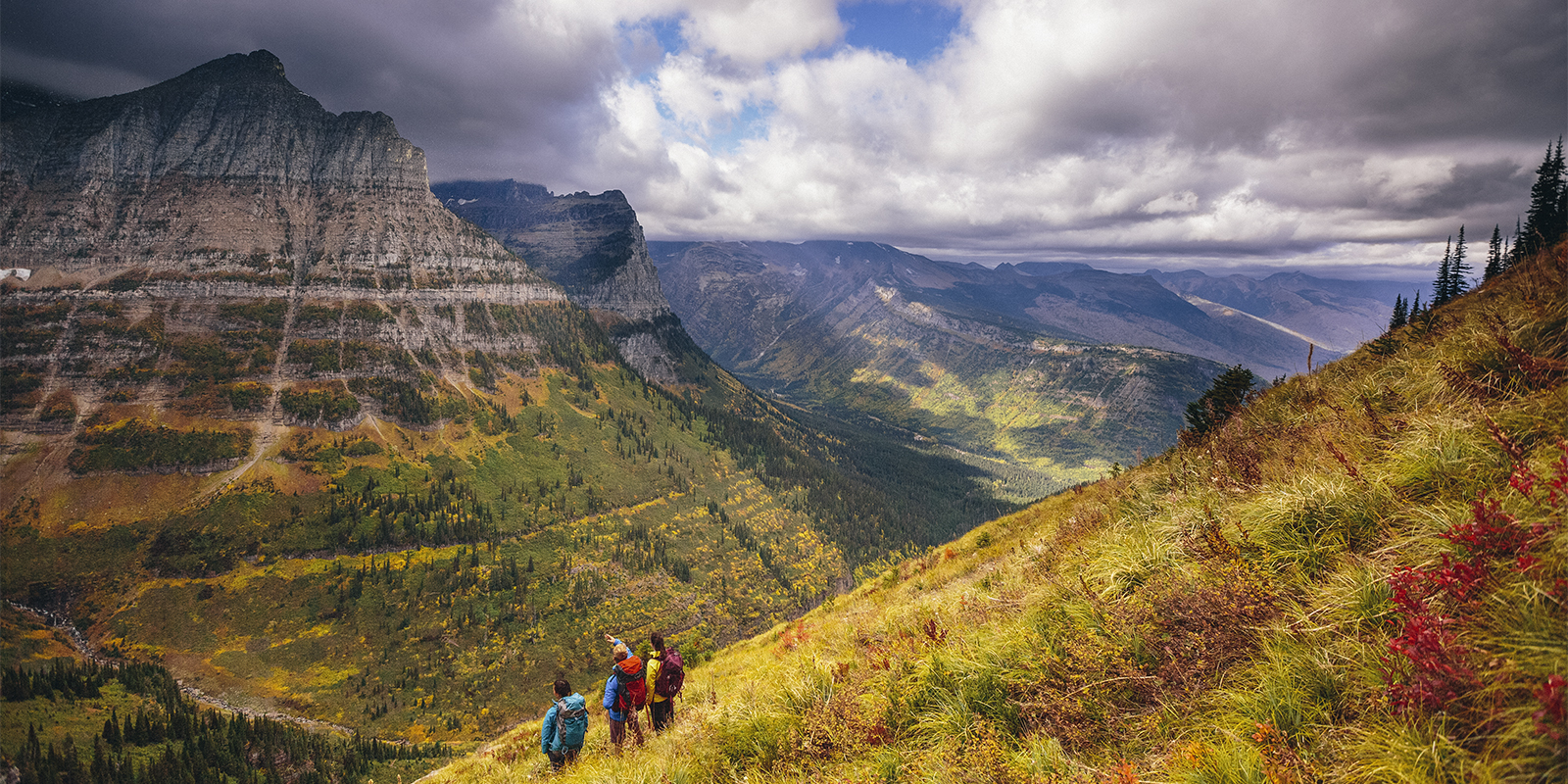
Meanwhile, there are 900 miles of trails, including a piece of the world-famous Appalachian Trail, 6,000-foot peaks to bag, and 2,900 miles of streams packed with waterfalls, swimming holes and trout. And situated within a day’s drive of more than 50% of the country’s population, GSMNP has something that many other national parks don’t have: accessibility. So yeah, everyone “knows” the Smokies, but the vast majority of those 12 million-plus annual visitors only see a fraction of what the park has to offer. Great Smoky Mountains has a reputation for being a “drive through” park, with a two-lane highway that cuts through the center of the property with a bevy of scenic pull-offs and short nature walks. But there are 500,000 acres to explore; if you stay in your car, you’ll only scratch the surface.
Prehistoric Paleo Indians called these mountains home, living a hunter/gatherer existence in the area roughly 12,000 years ago. By the time the first European settlers saw what would become the park in the 1700s, the Cherokee had already spent 1,000 years establishing permanent towns, cultivating cropland and developing an extensive system of trails. Today, the Qualla Boundary, home to the Eastern Band of Cherokee, sits adjacent to the park.
The Scotch-Irish settled the area, hunting and farming in the valleys between the mountains. As the population grew, the U.S. government removed the Cherokee by force to Oklahoma in the 1830s, an event known as the “Trail of Tears.” In the early 1900s, timber companies moved into what is now the park, establishing company towns and making quick work of the timber throughout the mountains. Roughly 80% of the forest was logged in the first part of the 20th century. The Great Smoky Mountains National Park was established in 1934, but not without another involuntary mass exodus; after relying on private donations to begin land acquisitions, the Tennessee and North Carolina state governments also used the power of eminent domain to seize control of smaller farms and properties, forcing 1,200 landowners from their homes, leaving behind their farms, mills, churches, schools and train tracks. Some of these structures have been protected, restored and can be seen in valleys throughout the park today. In fact, GSMNP has the largest collection of human artifacts of any national park.
As noted, Great Smoky Mountains is the most heavily used national park. Blame the location (within a day’s drive of some of the biggest cities on the East Coast) and the user-friendliness (much of the park can be seen from your car). The park straddles two states, with Sugarlands Visitor Center in Tennessee, and Oconaluftee Visitor Center in North Carolina, serving as the main entrances. These facilities sit on either side of Newfound Gap Road, a 29-mile-long highway that bisects the park, acting as the main thoroughfare. You don’t need reservations to visit the park and there are no entrance fees required either. You’ll find crowds at the visitor centers, along Newfound Gap Road and at popular trailheads, like Chimney Tops and the Appalachian Trail. But if you’re willing to hike a few miles into the backcountry, you’ll leave the crowds behind and have the park all to yourself.
Though a relatively mild season in the Southern Appalachians, the Smokies lay claim to a string of 5,000- and 6,000-foot peaks that often boast brutally cold conditions. Mount LeConte (6,593’) is often covered in ice and snow during winter. You can even find cross-country skiing on the 7-mile road to Clingmans Dome, which sits above a mile in elevation and is not plowed during the winter. Some of the park’s campgrounds and facilities are shut down during the winter, and Newfound Gap Road can often be closed due to ice and snow. Or, it could be 55 degrees, sunny and you could have the park mostly to yourself. Be sure to check conditions before you arrive.
The Southern Appalachians are famous for their largely hardwood canopy which turns technicolor in the fall, sheds leaves in the winter, and comes back to life in the spring. The forest is a vibrant shade of baby green in the spring, while wildflowers punctuate the forest floor; there are more than 1,500 flowering plants inside the park, most of which are blooming between March and June. Meanwhile, elk are giving birth to calves, a miracle that can occasionally be witnessed in Cataloochee Valley, where many elk gather. The weather can be fickle, though, with lows in the 30s and highs in the 60s (often during the same day) and often rainy. More Info: nps.gov
Undoubtedly the most crowded time to visit the park, it’s also arguably the most vibrant. Wildlife is active, increasing your chance to see large species like black bear and elk, and tiny species like fireflies. Speaking of which, there are 19 different species of fireflies living inside the park, including one species of synchronous firefly that shine in unison during a three-week window in summer. The flame azaleas, which bloom white and pink, also kick into high gear in June. Expect highs in the 80s, afternoon rain showers, and crowds in the campgrounds.
You want to see the Southern Appalachians at their most colorful? Visit GSMNP in October as the hardwood canopy turns bright shades of red, yellow, orange…even pink. Crowds are still thick, but typically only on weekends; if you can arrange for a mid-week visit, you won’t have to elbow your way through a trailhead. Temperatures are mild and dry and most of the campgrounds stay open until November.
Great Smoky Mountains National Park is not the destination for you if you’re looking for adrenaline-fueled adventure sports (no climbing allowed and cycling is only recommended on certain roads), but if you’re looking to hike, camp or take a scenic drive, this park has plenty of options.
GSMNP is a hiker’s dream with 900 miles of trails within its borders, including 71 miles of the world-renowned Appalachian Trail.
This 5-mile round trip takes you to an 80-foot-tall amphitheater of a cave dubbed Alum Cave Bluff. The views are stupendous, and the tread is fairly technical with some exposure and 1,200 feet of climbing. More Info: hikingproject.com
You can hike all 71 miles of the AT through the park if you want, or you can tackle this 6.5-mile out-and-back that begins at Newfound Gap and climbs steadily, offering periodic long-range views and wildflowers in season. After 2.7 miles, it branches off to hit the rocky outcropping dubbed “the Jump Off” on the face of Mount Kephart, with big views of Mount Guyot and the ridgeline traced by the Appalachian Trail. More Info: outdoorproject.com
The 100-foot-tall Ramsey Cascade is the tallest waterfall inside the park, but you have to work to get there on an 8-mile strenuous out-and-back that gains 2,000 feet in elevation. Along the way, you’ll pass through an old-grown hardwood forest with large tulip trees. More Info: nps.gov
You shouldn’t spend all of your time driving through the Smokies, but GSMNP was designed in part with cars in mind—a number of dramatic destinations and historic landmarks can be seen from the seat of your vehicle.
U.S. Route 441 cuts through the middle of the park for roughly 30 miles, climbing to 5,046 feet in elevation at Newfound Gap halfway through the journey. You’ll pass a series of overlooks and have the chance to take plenty of short hikes. Take a detour and drive Clingmans Dome road and walk to the top of Clingmans Dome, a concrete lookout tower with 360-degree views of the park.
This 14-mile one-way, mostly gravel road takes you deep into the backcountry on the eastern edge of the park, far from the crowds. You’ll start at 5,535 feet at the end of the Blue Ridge Parkway and drop 2,000 feet in elevation as you move from the ridgeline down to the valley.
Drivers get a little bit of everything on this 8-mile paved road, passing a waterfall and trout stream, old-growth hemlock trees and a historic grist mill.
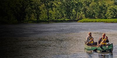
There’s a lot of water inside the park (2,900 miles of streams), from remote headwater streams that support wild brook trout to larger rivers ripe with smallmouth bass. Fishing is allowed year-round on all of the streams inside the park (get a license for either Tennessee or North Carolina), and there’s a five fish per day limit. If you’re looking for brown, rainbow or some of those wild brook trout, try Hazel Creek in North Carolina, or Abrams Creek in Tennessee. More Info: nps.gov
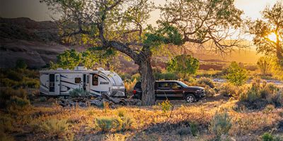
There are 10 frontcountry campgrounds located inside GSMNP, two of which (Cades Cove and Smokemount) are open year-round. You’ll find restrooms, running water, and campsites with fire grates and picnic tables at each site, but no showers or electrical or water hookups for RVs. All developed campgrounds inside the park require reservations, which you can make up to six months in advance. There are more than 100 backcountry campsites within the park, including several wooden shelters along the Appalachian Trail. You have to make advanced reservations for a backcountry site and get a General Backpacking Permit. More Info: nps.gov (frontcountry), nps.gov (backcountry)
All articles are for general informational purposes. Each individual’s needs, preferences, goals and abilities may vary. Be sure to obtain all appropriate training, expert supervision and/or medical advice before engaging in strenuous or potentially hazardous activity.