
5 Top National Parks for Fishing
These five parks are best viewed from the water’s edge.
Photo: Michael DeYoung/TandemStock
In 1965, President Lyndon B. Johnson addressed Congress about a subject that seems even more pressing today: the need to prevent the country’s growing population from “swallowing up areas of natural beauty.”
Then as now, America’s national parks were suffering from overcrowding and “areas of recreation and pleasure” were increasingly burdened with an overwhelming number of visitors. President Johnson appreciated the demand, but took issue with the supply. He wanted to protect what he saw as a critically important resource: the ability for the people of the United States to access and enjoy the outdoors.
He was concerned that more people were crowding into cities “and being cut off from nature,” and that development was wiping out green spaces. The president advocated for a new style of conservation that encouraged easy access for all no matter social status, race, or zip code.
The solution in the president’s mind was simple: a system of trails that spanned the country.
“The forgotten outdoorsmen of today are those who like to walk, hike, ride horseback, or bicycle. For them we must have trails as well as highways,” said President Johnson. “I am requesting, therefore, that the Secretary of the Interior work with his colleagues in the Federal Government and with State and local leaders and recommend to me a cooperative program to encourage
a national system of trails, building up the more than hundred thousand miles of trails in our national forests and parks.”
The result was the National Trails System Act, which passed in October 1968. The Act created four classes of trails: National Scenic Trails, National Historic Trails, National Recreation Trails, and side and connecting trails.
The act did a number of things. First, it designated two existing trails, the Appalachian Trail and the Pacific Crest Trail, as the country’s inaugural National Scenic Trails. Second, it called for 14 other routes to be studied for potential inclusion in the system (trails can only be designated by an act of Congress). The act also called for trails to be established “near the urban areas of the Nation” in addition to scenic or historical routes in more remote locations. The point was to provide people with more accessible opportunities for recreation by creating a system of mostly non-motorized, contiguous trails that extend for 100 miles or more all over the country. These long-distance trails were envisioned as being a collaborative effort between the government and local volunteers, nonprofit trail groups, and various local, state, and federal agencies.
Today there are 11 National Scenic Trails that collectively encompass a staggering 24,600 miles. In this piece we’ll get to know each one, and elsewhere on this site you can learn more about the gear and skills you need to explore them.
 Photo: Jason Hatfield/TandemStock
Year Designated: 1968
Miles: 2,190
States: ME, NH, VT, MA, CT, NY, NJ, PA, MD, WV, TN, VA, NC
Trail Group: The Appalachian Trail Conservancy
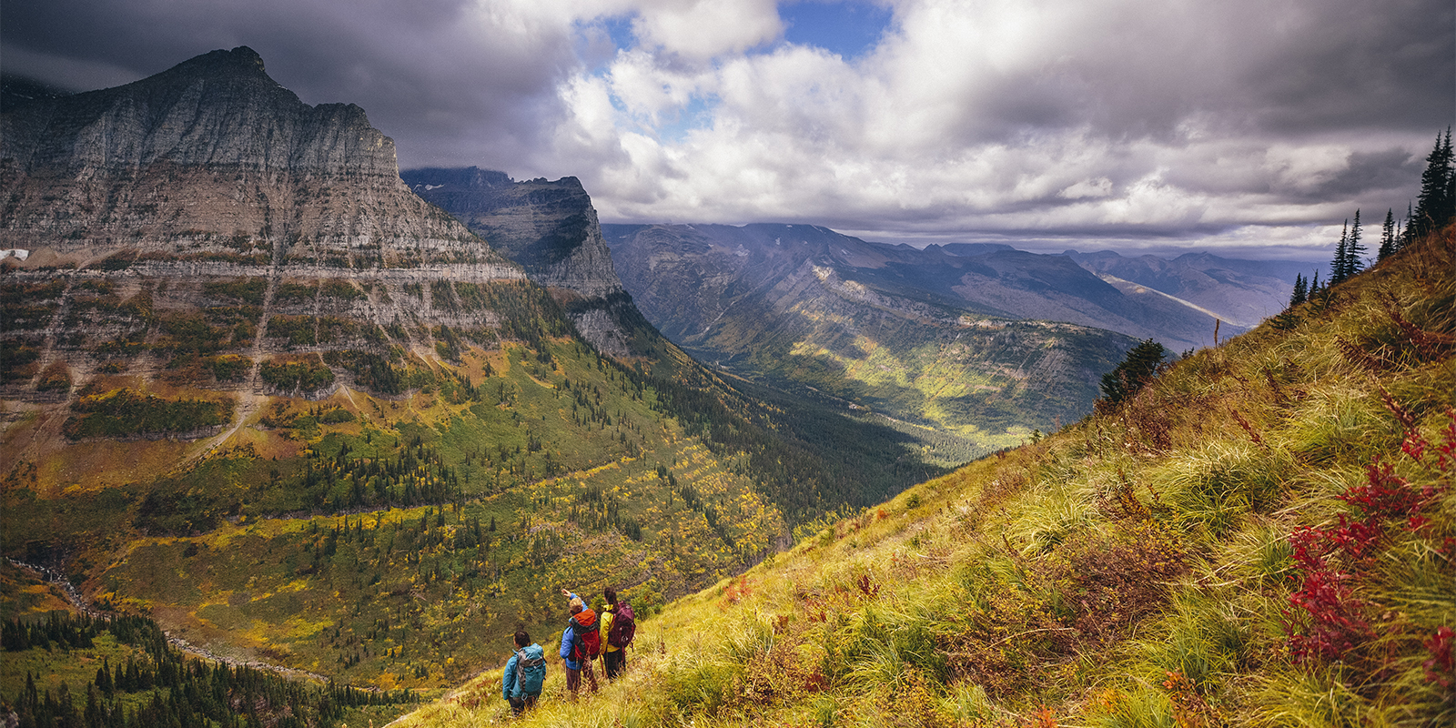
From Springer Mountain in Georgia to Mount Katahdin in Maine, the 2,190-mile footpath traverses the forests and peaks of the Appalachian Mountains and crosses 14 states. The de facto founder of the trail, Benton MacKaye, laid out a proposal for the trail in the 1921 Journal of the American Institute of Architects. The first person to hike the entire trail in a single season was Army veteran Earl Shaffer. In 1948 he spent 124 days walking “the army out of [his] system.” Upon finishing he wrote that he “almost wished that the Trail really was endless, that no one could ever hike its length.” Since then thousands of people have set out to do what Shaffer did, and today the AT is one of the most famous thru-hikes in the world. The trail crosses rivers, traverses rocky mountain tops, and tunnels through lush forest. Along with the Continental Divide Trail and the Pacific Crest Trail, the AT is one-third of the thru-hiking trifecta known as the Triple Crown; in the tight-knit community of long-distance hikers, the few individuals who have hiked every mile of all three trails are reverently called Triple Crowners. In President Johnson’s 1965 speech he was inspired by the AT, saying, “We need to copy the great Appalachian Trail in all parts of the country.”
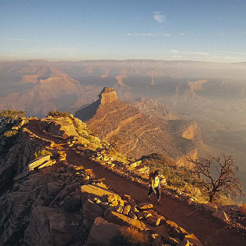 Photo: Justin Bailie/TandemStock
Year Designated: 2009
Miles: 800
States: AZ
Trail Group: The Arizona Trail Association
The 800-mile Arizona Trail traverses the state from the U.S./Mexico border to the state’s border with Utah and is one of the newest National Scenic Trails. It links a variety of diverse landscapes, from deserts and canyons to mountains and forests. The trail crosses such natural beauties as the Sonoran Desert, the Gila River, the Superstition Mountains, and the Mogollon Rim, and goes from rim to rim in the Grand Canyon and up to the Kaibab Plateau before ending at the swirling sandstone at Vermillion Cliffs National Monument. The Arizona Trail was dreamed up by Dale Shewalter in 1985 after he walked north from Nogales, at the southern edge of the state, to the Utah state line. After that he started giving presentations on his vision of a grand trail that connected the state’s communities and landscapes. The Arizona Trail Association was founded in 1994 and was integral in the creation of the trail, from the planning and developing to the actual construction and maintenance of the trail.
 Photo: Michael DeYoung/TandemStock
Year Designated: 1978
Miles: 3,100
States: MT, ID, WY, CO, NM
Trail Group: Continental Divide Trail Coalition
The Great Continental Divide separates the watersheds that drain into the Pacific, Atlantic, and Arctic Oceans, making it the geological centerpiece of North America. The Continental Divide Trail follows this geographical feature along the spine of the Rockies for 3,100 miles, from the Canadian border to the Mexican border. As it crosses five states it travels through communities like Pie Town, New Mexico, (yes, there’s pie there) and across remote landscapes like Weminuche Wilderness in southwestern Colorado––one of the trail’s longest roadless sections and the largest wilderness area in the state. It’s the highest of the 11 National Scenic Trails––elevations on the CDT range from 4,000 to 14,000 feet at the summit of 14,270-foot Grays Peak in Colorado. The CDT was included as one of the trails to be studied for designation in the 1968 National Trails System Act and it was officially designated 10 years later.
 Photo: Mac Stone/TandemStock
Year Designated: 1983
Miles: 1,500
States: FL
Trail Group: The Florida Trail Association
The Florida Trail stretches 1,500 miles across the state from the Gulf Islands National Seashore to Big Cypress National Preserve. The trail navigates diverse terrain: white sandy beaches, steep ravines, palmetto forest, swamps, civil war battlefields, and the winding Kissimmee River. The idea for the trail was conceived by Jim Kern in 1966. He had long grown tired of driving to other states, like North Carolina, to go hiking. He wanted to know: why weren’t there any great hiking trails in Florida? “I felt very strongly that Florida was missing out not having any footpaths,” said Kern at the time. “The Forest Service thought it was all a joke. They told me ‘go ahead and do your thing. But, no one will want to hike in Florida.” Kern and his efforts generated some publicity and the Florida Trail Association was born, with the original goal of building a continuous 500-mile hiking trail. They completed the first 26 miles in 1969, the trail was designated in 1983, and today volunteers put in tens of thousands of hours maintaining the trail for all to enjoy. (However, it’s important to note that the Florida Trail, like most National Scenic Trails, has significant gaps; the Appalachian Trail is the only one that is a protected trail from end to end.)
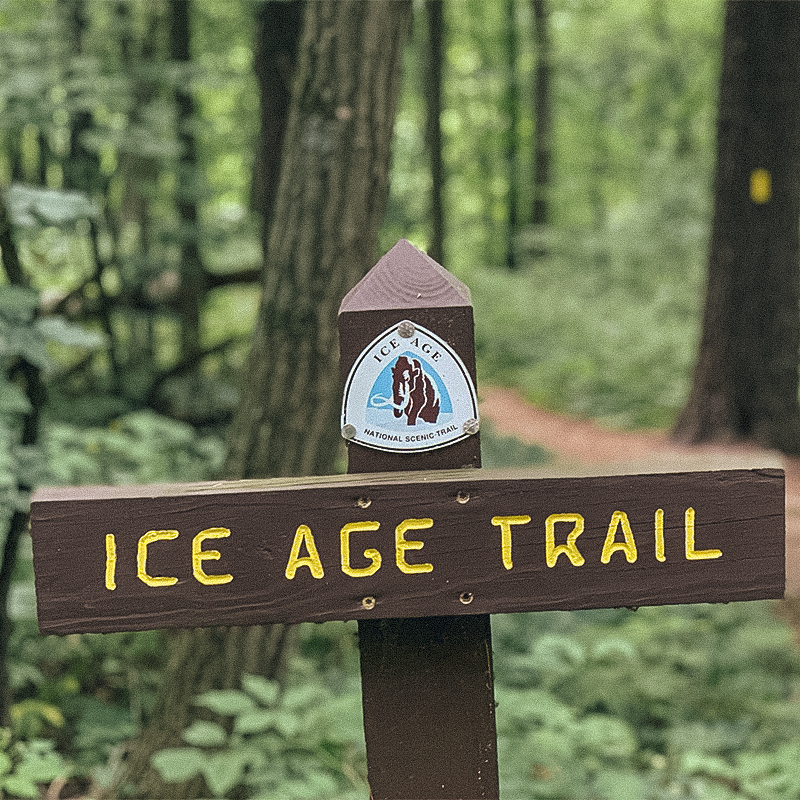 Photo: Wisconsin DNR
Year Designated: 1980
Miles: 1,200
Staes: WI
Trail Group: Ice Age Trail Alliance
Wisconsin is the ideal place to examine the remnants of the last Ice Age, which took place some 15,000 years ago, at a time when much of the continent was covered by a glacier and mammoths and saber tooth cats roamed. The 1,200-mile trail and its hills, valleys, forests, prairies, and lakes trace the edge of where the glacier once was. The footpath travels through 30 counties from Interstate State Park in St. Croix Falls along the St. Croix River and the border with Minnesota, to Potawatomi State Park. The trail was the vision of Ray Zillmer, who dreamed of a long park that wound along the glacier’s terminal moraine. The trail was built by volunteers and is largely maintained by volunteers.
All articles are for general informational purposes. Each individual’s needs, preferences, goals and abilities may vary. Be sure to obtain all appropriate training, expert supervision and/or medical advice before engaging in strenuous or potentially hazardous activity.
 Photo: Marc Muench/TandemStock
Year Designated: 1983
Miles: 65
States: MS, TN
Trail Group: Natchez Trace Parkway Association
At 65 miles, the Natchez Trace Trail is much shorter than the others on this list but has a rich history that’s connected to a much longer path. The Old Natchez Trace was about 500 miles long and connected what’s now Mississippi and Tennessee. People have walked what once was a well-worn stretch of trail for thousands of years. Many Indigenous people traveled amongst the hardwood forests and wetlands, including the Choctaw, Chickasaw, and the Natchez. The historic trail itself was created by the Native Americans who lived in the area and was later used by early explorers in the 1700s and 1800s. The 65-mile trail has five different segments that are parallel to the 444-mile Natchez Trace Parkway, a popular scenic drive.
 Photo: Gallogly/TandemStock
Year Designated: 2009
Miles: 215
States: CT, MA
Trail Group: Appalachian Mountain Club and Connecticut Forest and Park Association
Another one of the newer trails in the system, the 215-mile New England Trail starts at the Long Island Sound in Connecticut and tags summits, traverses ridgelines, and passes through 41 communities on its way to Massachusetts. This long-distance trail is largely made up of the existing Mattbesett, Metacomet, and Monadock (M-M-M) trail systems, which follow the Metacomet Ridge, a nearly continuous line of basalt rock. Along the way hikers can explore iconic places like the historic Heublein Tower in Hartford and the summits of the Seven Sisters in the Mount Holyoke Range. A major emphasis when creating these trails was that they are close to population centers and are accessible to a lot of folks. The New England Trail achieves that goal: 2.5 million people live within 15 miles of the trail.
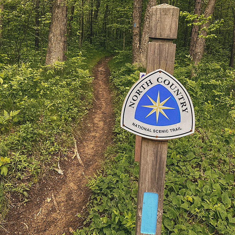 Photo: Dominic Goyette/North Country Trail Association
Year Designated: 1980
Miles: 4,600
States: MI, MN, ND, NY, OH, PA, WI
Trail Group: North Country Trail Association
The North Country trail is another path that the 1968 act wanted to consider for National Scenic Trail inclusion, and it was finally designated in 1980. The trail winds along a few of the Great Lakes, through urban areas, and past farms and forests and rivers. At a staggering 4,600 miles long, it’s by far the longest of all the trails in the system (though 1,500 miles of it have yet to be completed). It crosses eight states, and more than 160 different federal, state, and local public lands including 10 national forests, four National Park Service sites, and more than 100 state parks and forests. It shares miles with existing iconic trails, like the Superior Hiking Trail in Minnesota, the Buckeye Trail in Ohio, the Finger Lakes Trail in New York, and the Iron Belle Trail in Michigan.
 Photo: Ethan Welty/TandemStock
Year Designated: 1968
Miles: 2,650
States: CA, OR, WA
Trail Group: Pacific Crest Trail Association
The PCT travels through Washington, Oregon, and California from the U.S./Mexico border to Manning Park, which is just over the border with British Columbia. The trail was designated in 1968, but wasn’t completed in its entirety until 1993 (some sections still lack long-term protection). Over its 2,650 miles, hikers pass through hot desert, the craggy and dramatic peaks of the Sierra Nevada, and the volcanoes of the Cascade Range in Oregon and Washington. The iconic John Muir Trail from Yosemite to Mount Whitney shares about 160 of its miles with PCT. Depending on the year and the weather, hikers attempting to complete the full trail will contend with extreme heat, snowfields, and all kinds of precipitation. The trail is friendly to day hikers too, as it’s readily accessible in parks up and down the PCT corridor. Clinton Clarke of California was one of the forces behind the creation of the trail and was responsible for the 1932 Pacific Crest Trail System Conference that promoted the idea of a long-distance trail from border to border (photographer Ansel Adams was a member of the conference’s executive committee). It took collaboration by a number of different groups and hiker organizations to figure out how to link existing trails (like the Cascade Crest and the JMT and the Oregon Skyline) together and to create new trails to connect each one.
 Photo: Ben Herndon/TandemStock
Year Designated: 2009
Miles: 1,200
States: ID, MT, WA
Trail Group: Pacific Northwest Trail Association
This rugged route roughly hugs the Canadian border as it snakes from Washington to Montana. The western terminus is near Cape Alava on the Pacific Ocean and its eastern terminus is near the Continental Divide in Montana’s Glacier National Park. Over the course of 1,200 miles, the trail crosses three national parks, seven national forests, and seven different mountain ranges. The idea for the PNW trail can be traced back to the conservationist and writer Harvey Manning, who dreamed of a hiking trail across the Cascades. A man named Ron Strickland read Manning’s 1970 book 101 Hikes in the North Cascades and had a vision of a trail spanning from the Continental Divide to the Pacific Ocean. Along with other volunteers he formulated a viable path and got national attention after Backpacker magazine ran an article requesting support for the trail. The Pacific Northwest Trail earned National Scenic Trail status as part of President Obama’s 2009 Omnibus Public Lands Management Act.
 Photo: NPS/ Monica Larcom
Year Designated: 1983
Miles: 710
States: DC, MD, PA, VA
The Potomac Heritage National Scenic Trail protects hundreds of miles of existing and planned trails across three states and the nation’s capital as it travels from the mouth of the Potomac River through Maryland’s Chesapeake Bay and the Appalachian Mountains of Pennsylvania. A number of different trails are included within the network, like the 18.5-mile Mount Vernon Trail and the 184.5-mile Chesapeake and Ohio Canal Towpath. This trail has a vibrant history and includes portions of the Underground Railroad. Of the 11 National Scenic Trails, the Potomac Heritage is also the only one that has a route for biking, hiking, and paddling. The trail also goes right through Washington D.C.––in fact, the trail fittingly passes right by the Lyndon B. Johnson Memorial.